[Advantage Logistics] Iran’s maritime authority has issued a new Traffic Separation Scheme (TSS) in the Strait of Hormuz to counter the risk of naval mines. This move directly invalidates the international transit corridor established by the IMO, simultaneously placing commercial vessels under the strict control of the Islamic Revolutionary Guard Corps (IRGC).
The Iranian maritime authority has officially promulgated a new Traffic Separation Scheme (TSS) for the Strait of Hormuz. The publicly stated reason for this adjustment is to “avoid the risk of collision with anti-ship mines.”
Prior to this, Western intelligence sources suggested Iran might have deployed dozens of naval mines in this shipping lane last month, although this allegation remains independently unverified and highly contested.
Through the state broadcaster (IRIB), Iran’s Ports and Maritime Organization issued an urgent directive: “Due to the war situation in the Persian Gulf and possible anti-ship mines in the main traffic zone of the Strait of Hormuz, vessels must to coordinate with the IRGC Navy and use the designated routes.”
Establishing an Exclusive “Checkpoint”
Under the new TSS diagram, inbound traffic will be directed to navigate through the area between Qeshm and Larak islands. This route has long been dubbed “Tehran’s toll booth” by maritime observers, as it falls under the absolute surveillance of the IRGC forces.
Meanwhile, outbound traffic will navigate just south of Larak Island. This lane lies entirely within Iranian territorial waters, creating highly favorable boundaries for IRGC patrol units to easily approach, conduct escort operations, execute security boardings, and perform vessel identification procedures.
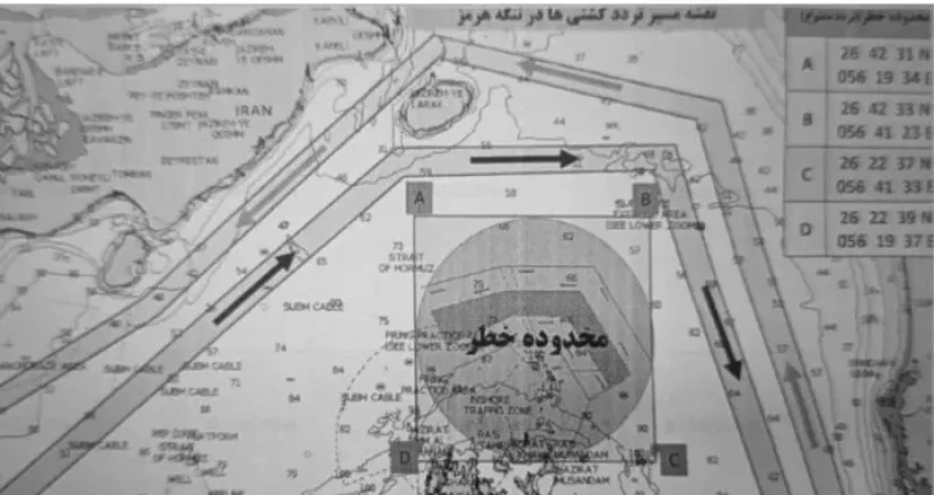
Invalidating the Standard IMO Route
The most alarming aspect for international shipowners is that this new maritime map establishes a “danger zone” with a “no-navigation” order overlaying the traditional deep-water transit corridor itself.
Specifically, the coordinates of this exclusion zone overlap the internationally recognized TSS established by the International Maritime Organization (IMO), situated just off the northern tip of the Musandam Peninsula.
Even more notably, this warning zone also appears to cover the recently operational Omani-administered shipping lane on the southernmost edge of the strait. This move directly contradicts the agreements on transit rights through Omani territorial waters that the two nations had previously discussed.
Tightening Control Despite the Ceasefire
Although the US and Iran have announced a ceasefire and an easing of maritime restrictions, in reality, the IRGC continues to exercise absolute control over Hormuz. AIS (Automatic Identification System) data reveals that very few commercial vessels dared to risk transiting the strait in the first 24 hours after the temporary truce was agreed upon.
The Strait of Hormuz – historically utilized by the international community as a free and unimpeded maritime corridor – is now being transformed by Tehran into a bargaining tool. Retaining the power to dictate terms at this vital energy chokepoint currently stands as one of Iran’s prerequisites for any long-term peace plan.
Source: Phaata.com (According to Maritime-Executive)
>> Other news:
>> 4 main types of services of Advantage Logistics:
>> Our contact:
-
-
- Address: 3rd Fl., 55 Nguyen Van Giai Str., Tan Dinh Ward, HCMC, Vietnam.
- Email: nicky@advantage.vn / truc@advantage.vn
- Hotline (cell/ zalo/ viber): 0909.054.866 (Mr.Quyền) / 0938.444.043 (Mr.Trực)
- Web: https://advantage.vn
-